
(Administrative Assistant)
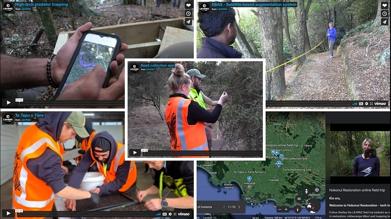
Hokonui Rūnanga Taiao team, along with Toitu te Whenua – Land Information New Zealand, Longford Intermediate, Te Tapu o Tāne, and our Kaitiaki tauira have been very privileged to be part of the latest video additions to the LEARNZ online field trips website, about the Hokonui restoration: Tech in te Taiao.
This filming opportunity allowed Kaiārihi Taiao Environmental Lead, Riki Parata to give an overview of what the Hokonui Rūnanga Kaupapa Taiao programme aim to achieve alongside their partnership with Toitu te Whenua – Land Information New Zealand. This involves current project activities like pest control, restoration planting increasing the ngahere, seed collection, and monitoring of taonga species. Paired alongside new location-based apps created by Toitu te Whenua (LINZ) that help locate, identify, and collate data for pest control, seed collecting and weed control projects.
LEARNZ powered by CORE Education filming crew Shelley Hersey (LEARNZ Kaiārihi) and Andrew Penny (LEARNZ videographer) spent three days in our takiwā uncovering what the Hokonui Rūnanga Kaupapa Taiao programme has to offer.
Find about more about LEARNZ Hokonui Restoration: Tech in Te Taiao and how your kura can get involved!
Filming began in the Hokonui Rūnanga Wetlands, where footage was taken of the Longford Intermediate ākonga, who have participated in the Wetland Restoration project to restore native plants that can be found within the Mataura/Gore takiwā.
The ākonga explained the process of planting, how protective barriers are used to shield plant life until maturity and the importance of weeding to encourage future growth.
Ravi Pitchika GIS Analyst for Toitu te Whenua (LINZ) offered a walkthrough of the weed control app. This technology has outdated the pen to paper method by allowing real time data input of invasive species, chemicals used, control methods, and the ‘track me’ button that pinpoints the areas that have been controlled. This data keeps time and date logs, allowing data to be sent to a web-based viewer where the data is stored, viewed, and collated.
We later made our way to the Mataura Falls where the kaitiaki tauira demonstrated the process of setting and releasing hīnaki.
Riki Parata explained the significance of the Mataura falls to mana whenua and how Hokonui Rūnanga Taiao are working with the Industry to restore this area. This involves Tuna (eel) surveying and Elver trap, track, and transfer, Kanakana (lamprey) monitoring, and the possibility of a bridge being built that can assist Kanakana making it over the falls.
The tauira then gathered the hīnaki set from the previous day, showing their capture of a longfin eel, which is an endangered taonga species. They measured and weighed the tuna, whilst Riki talked about the 8km stretch of Mataura Mātaitai reserve where tuna surveying will be carried out by our tauira, indicating tuna present within and outside of the Mātaitai.
Later in the day, tauira team leader Raniera Smyth discussed the importance of pest control, and how this mahi can protect our native plant life and native species. He mentioned how the Field Maps app created by Toitu te Whenua (LINZ) was helpful for him and fellow tauira while doing pest control in the Hokonui Hills. The app allows the tauira to track lines, mark hazard points, mark trap placements, and image taking of traps and hazards. This data is then synced to all other tauira devices, providing an easy way to share and keep records of trapping data and more.
Ravi added to this, by mentioning Toitu te Whenua partnership with GIS Australia, with their joint project SBAS – Satellite-based augmentation system. Here they are working on improving location-based apps to improve the location accuracy which currently stands at a 5-10 metre radius and aim to improve this by narrowing down the radius to 1 metre or under.
Mollie Lyders Kaitiaki Taiao (Environmental Assistant) explained the process of seed collection, how the seed collecting app created by Toitu te Whenua is utilised to track seeds via GPS. Once seeds are matured and sold, the owner can trace the plant back to its origins, the species name and who collected them and at what time. She explains the importance of eco-sourcing, which provides the owner with information about which specific areas native species can thrive, and areas where they may be considered an invasive plant. Through seed collecting, Mollie mentions the large seed bank which has been collected, processed, and will be passed onto Te Tapu o Tāne the nursery project.
Jana Davis, Chief Executive of Te Tapu o Tāne nursery, gave an overview of their goals they aim to achieve, like regenerating our whenua, working with communities, providing pathway for rangatahi, to name but a few.
Jana went on to explain the importance of eco-sourcing, as he states, “plants thrive better when they go back to where they come from”.
The Hokonui Rūnanga Seed Collecting crew send seeds to the nursery where Te Tapu o Tāne will log, catalogue and on occasion clean seeds that need further cleaning before processing them. It is important to track these batch numbers, the area the seeds were collected, serial numbers, species type and its taonga, common and Latin names, which is where technology plays a huge role with its web-based viewer. Jana voiced how he would like the App to be able to be interactive, so the community can log in online and see where the plant has come from, who has collected them, and who has grown them.
He finished the day off with his closing remarks by encouraging future generations to educate themselves, absorb the knowledge in order to give back to and improve our whenua.